Red Snapper Sink USA
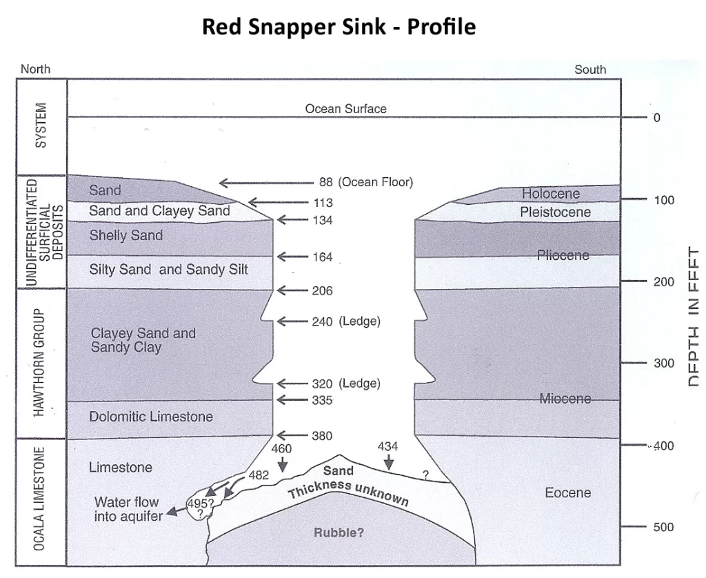
Red Snapper Sink emerges in the Atlantic Ocean, submerged in water approximately 88 feet deep. A unique geological feature, it forms a funnel shape descending to a depth of around 150 feet before plunging vertically to as deep as 465 feet.
- Region: Florida
- Coordinates: 29.74056, -80.74778
- Depth: 482 ft
- Remarks:
- Type: Cave
Curious Transition
While once believed to be a freshwater spring, Red Snapper Sink’s water samples from depths of 465 feet did not confirm this notion. Some experts, including Kohout and others (1975), propose that the sink may now serve as a point of seawater intrusion into the Floridan Aquifer. This assertion is supported by the high oxygen content of the deeper water within the sink and the results of a dye-dispersion test, which hint at a subtle downward flow of seawater.
Unveiling the Depths: Technological Advancements
In 1991, advanced technical-diving techniques led to the exploration of Red Snapper Sink’s bottom for the first time. The sinkhole’s entrance, found at 90 feet below the ocean’s surface, spans about 400 feet in diameter. The greatest depth recorded within the sinkhole reaches 482 feet.
Geological Marvels of the Sinkhole
The sinkhole’s walls showcase diverse geological layers, revealing a journey through time. The sides are etched in loose Holocene sand and shell from 88 to 113 feet, followed by Pleistocene sand and clayey sand from 113 to 134 feet. Moving deeper, from 134 to about 380 feet, the sink transitions into a vertical shaft, spanning 150 feet in width to 170 feet in length. The walls feature different strata, ranging from indurated Pliocene shelly sand to Miocene clayey sands and sandy clays.
A Unique Conduit of Fluids
During an exploratory dive to 482 feet, saltwater was observed entering small caves at the base of the sinkhole’s wall. This intriguing observation signifies that Red Snapper Sink facilitated the conveyance of saltwater into the Floridan aquifer system during the dive. Seismic profiles suggest that the sink is a surface manifestation of a dissolution collapse feature that may have originated in Upper Cretaceous or Paleocene rocks.
Unraveling the Hydrological Mystery
The presence of similar buried features in northeastern Florida could serve as hydraulic connections between freshwater zones and deeper, more saline sections of the Floridan aquifer system. These features might provide insights into the unusual distribution of elevated chloride concentrations in parts of eastern Duval County.
The presence of similar buried features in northeastern Florida could serve as hydraulic connections between freshwater zones and deeper, more saline sections of the Floridan aquifer system. These features might provide insights into the unusual distribution of elevated chloride concentrations in parts of eastern Duval County.
FAQ
Red Snapper Sink reaches a maximum depth of approximately 482 feet.
No, Red Snapper Sink is not accessible to the public due to its underwater location and technical diving requirements.
Red Snapper Sink is a submerged funnel-shaped sinkhole in the Atlantic Ocean, possibly indicating seawater intrusion into the Floridan Aquifer.